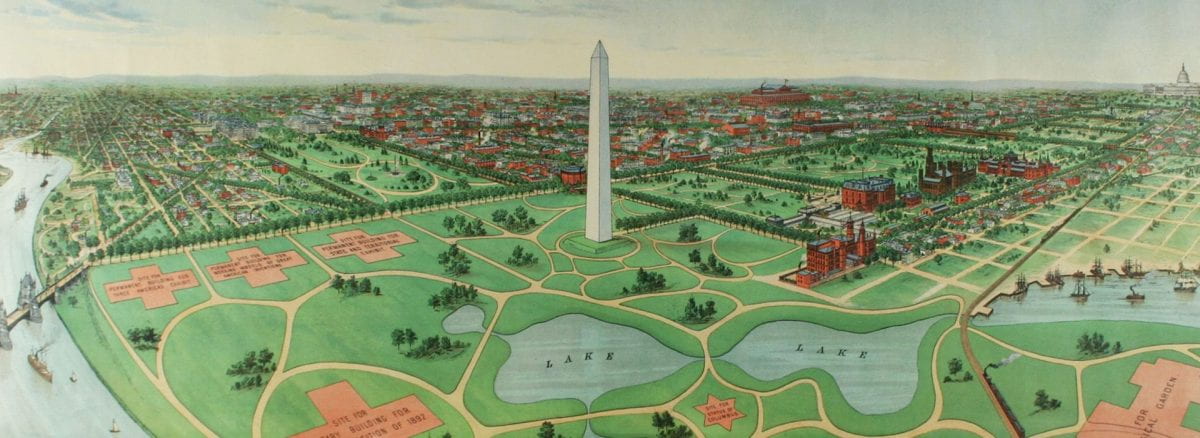
During the 1870s, the city of Washington embarked on an initiative to transform the National Mall from wetlands into a park. The city covered over parts of the Washington City Canal, including the Tiber Creek section, which once flowed where Constitution Avenue is located today. The Army Corps of Engineers dredged the Potomac River and used the material as backfill – adding over 700 acres to the Mall. By the late 1880s, city leaders were ready to propose hosting the World’s Fair of 1892 to mark the 400th anniversary of Columbus’ arrival in the New World.
This print promotes Washington as the host city for the fair. The bird’s-eye view of the proposed site centers around the Washington Monument, which was completed in 1888 and was the tallest structure in the world at the time. Additional sites depicted in the print include a temporary building for the World’s Exhibition, the national zoo, three permanent buildings for a state and territorial exhibit, working models of American inventions and a “Three Americas” exhibit.
On the left is a proposed stone Gothic Revival bridge connecting B St. NW – now Constitution Avenue – with Virginia. On the right is the railroad line across the Potomac River, connecting Virginia with railroad stations on the Mall – all good transportation routes to the fair. The plan also included four lakes with a statue of Columbus in the middle. After much debate, the fair was eventually awarded to Chicago as the Columbian Exposition of 1893.


